
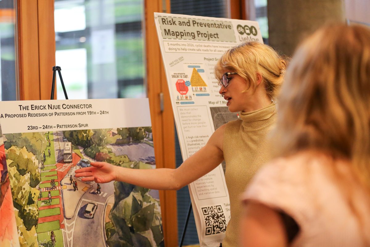
The student-created LiveMove is a mapping project that seeks to identify high-risk areas in Eugene for pedestrians and cyclists, which will eventually culminate in a presentation to the city, using the data to advocate for safer roadways.
Cat Colson and Hannah Norris were alarmed by rising traffic deaths in Eugene over the past several years, so they decided to create a survey that lets community members report where they were almost hit or hit while using non-car forms of transportation, like walking or biking.
The study, which has accumulated over 100 responses since its launch approximately two months ago, is designed to be a simple and accessible way to report near-misses and crashes instead of going through a police department.
The Eugene Police Department has a system for reporting roadway complaints, and while Colson and Norris aren’t opposed to the department’s data collection, they think having an alternative to the official system is an important step to representing all community members.
“It’s community-focused and not associated with police or officials so we can represent those marginalized by the justice system,” Colson said.
Using data from the Oregon Department of Transportation, the city currently only tracks crash data and not data on near-misses, something that the LiveMove team calls “reactive.” This crash data, usually collected only after injury or death has occurred, is accumulated into a high-crash network and is used to determine which roadways should be prioritized for improvements.
While LiveMove thinks this data can be helpful, they are hoping to accumulate more than one type of data and track more experiences by collecting near-misses at intersections and roadways before crashes occur, which will allow them to identify the most dangerous places for cyclists and pedestrians.
“Before decisions can be made there has to be data collection and so we’re trying to see how accurate the high-impact networks are,” Colson said.
Norris said their informal study is filling a “silent demand” for making streets safer.
“This data is under the radar and under-reported but it’s not less important,” Norris said.
While grateful for the growing number of responses, Norris and Colson were particularly excited to see that respondents are also providing testimony on their experiences on the roadway.
The survey is anonymous but the team hopes that it gives voice to underlying transportation issues and can be shared with city officials looking at what roadway changes should be made.
“People have a lot to say in their testimony about their experience biking and it is valuable insight and doesn’t fit into the (official) reporting system,” Norris said.
The survey can also be used as a simple alternative to going to city council public comment sessions, which some community members might not have the time to do.
The LiveMove team has presented their findings to members of the UO community at a planning, public policy and management departmental poster session and hopes to share the data with the policy makers trying to end Eugene traffic deaths as part of the “Vision Zero” plan.
“I think there might be incidents that we’ve collected that they don’t have and, at the very least, I would like to share that with them when deciding what streets are a priority,” Norris said.
Norris said it’s important that the engineers and planners designing roadways “see the full picture” of what traffic safety means in Eugene, and she thinks the city incorporating LiveMove’s data is a great way to do this.
Marion Suitor, a spokesperson for the Eugene’s public works department said that the city received LiveMove’s data and is considering all input and its traffic safety teams are talking with several “stakeholders” on road design.
Colson said that next year she hopes to get “more minds working together” on the project so that higher-volume data can be quickly organized and the team can come up with creative solutions.
LiveMove is also partnering with transportation groups throughout Eugene and Lane County, including Better Eugene-Springfield Transportation and Lane Transit District, to see how their data can be put to use.
“The community is receptive and supportive. So far we have gotten a load of positive feedback,” Norris said.
To build a more comprehensive database, they want to distribute fliers for the survey beyond the campus and West Eugene areas, and provide residents with physical survey copies.
“I don’t blame the system for not having an integrated near-miss system. It is a gray area, but it’s super important because we don’t have to wait for people to crash and get hurt or die,” Norris.
Editor’s note: A previous version of this article incorrectly listed Marion Suitor’s last name. The Emerald regrets this error.


RC • Jun 9, 2026 at 8:36 am
My question is whether they are taking into account when an incident is caused by a cyclist or pedestrian doing something that they shouldn’t have been doing. I’m a driver and pedestrian. I used to ride a bike. I’ve never had a near miss as a pedestrian or cyclist. Every near miss I’ve had as a driver was because the cyclist or pedestrian made a bad and dangerous choice.